NAURU


O Nauru 500C ISR é um drone para aplicações de segurança patrimonial, desenvolvido para missões de Inteligência, Vigilância e Reconhecimento (ISR). Projetado para operações BVLOS acima de 400ft, oferece 4 horas de autonomia de voo e suporte a sistemas completos de ISR, tornando-se uma ferramenta essencial para segurança pública e privada.Como o primeiro drone VTOL certificado pela ANAC e autorizado para voos noturnos, o Nauru 500C ISR combina a eficiência de um asa fixa com a flexibilidade do VTOL (Vertical Take-Off and Landing), permitindo operações fáceis e seguras em áreas complexas.

Surveillance of up to 2500km² per daytime flight¹.
Surveillance of up to 1000km² per night flight¹;
Payload: SIS132B (electro-optical camera, LWIR infrared sensor and rangefinder), XM3 (RGB) and XM5 (multispectral) 26 MP aerophotogrammetric sensor.
4-hour flight.
Up to 60km range (in Direct View).
Typical cruising speed: 48kt.
VTOL (Vertical Take-Off and Landing) system.
Modular design for efficient logistics.
Stealth: low-audibility propulsion system and low-observability paintwork.
¹ Daytime considering 3.5 hours of surveillance, recognition of humans on both sides (scanning). both sides (scanning). Night considering 3.5 hours of surveillance, detection of humans on both sides (scanning).
The only drone in Brazil authorized to fly BVLOS and above 400ft. 100% national manufacturing


VTOL technology for landing and taking off in hostile environments
With the operational environment of Nauru 500C ISR customers in mind, Xmobots was one of the world's pioneering companies in the development of the VTOL (Vertical Take-Off and Landing) system for high-performance UAVs.
The use of technology allows operations to be carried out in environments such as forest clearings, ports, border areas and other confined places, without the need for a runway or open field for landing and take-off procedures. Allied to this facility, the hybrid system with a combustion-generated engine allows the Nauru to have an autonomy of 4 hours, making it possible to cover a large area with continuous monitoring.
Development supported by FINEP
The development of the Nauru 500C is strategic for Brazil. Whether for territorial defense or for the development of the national economy, Brazil's largest technology and innovation promotion institution is one of the Nauru's supporters, through Research and Development projects focused on improving the product.
Night flights for strategic missions
The Nauru 500C is the only UAV authorized by ANAC to fly at night in Brazil. Considering that this is the time of day when crime is most likely to occur, the authorization obtained by ANAC represents a major achievement for Xmobots and its customers, who can now count on the 24x7 availability that only the Nauru offers.
+ Intelligence in the fight against crime
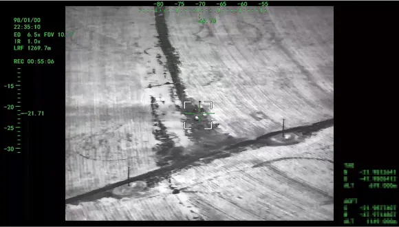
ISR missions require rapid responses. The more precise and detailed the images, the more efficiently the teams on the ground can be directed, generating effective results in the fight against crime.
To ensure that no suspicious movement goes unnoticed, the Nauru 500C has a gyro-stabilized sensor system with high target tracking performance. Day or night, the Nauru is always ready to reinforce the security apparatus of Xmobots customers.
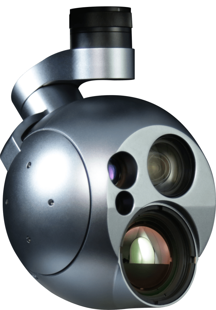
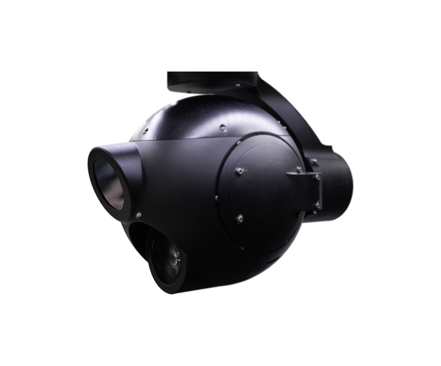
SIS132B Stabilizer Camera
Operations with the Nauru 500C ISR often take place in critical areas, such as forests, river borders, the sea, areas with high population density, disaster areas, among other highly vulnerable operational environments. Whether due to difficult access or even security issues, monitoring with a high-performance UAV is the only viable option for combat teams. For this reason, your camera system needs to capture targets accurately, with low image transmission times and high coordinate precision.
A câmera giroestabilizada SIS132B possui sensor eletro-óptico (visível) FHD com 30X de zoom ótico, e sensor infravermelho termal (LWIR) SD com lente de 50 mm. O equipamento possui capacidade de transmissão de vídeo com baixa latência (<300 ms) simultânea de ambas as câmeras em h.264. Possui sensor laser range finder para aquisição da coordenada geográfica dos alvos em solo, funções ICR para operações noturnas, função de rastreamento automático de alvos e apontamento georreferenciado. Os sensores são instalados em uma torreta giroestabilizada (sensor) de 3 eixos, com estabilização em roll, pitch, yaw, e controle de elevação e azimute (360 graus contínuos). O equipamento é adequado para missões ISTAR diurnas e noturnas.
These features allow targets to be detected and tracked even at high altitudes and at distances of more than a kilometer, providing greater safety for the pilot and sensor operator.
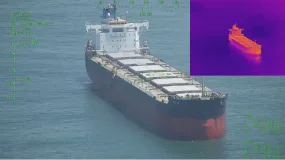


Real-time detection, recognition and identification of targets such as fire outbreaks or intruders
SIS 132B (EO + LWIR) for day and night missions
Daytime detection
Night detection
Humans detected at 16 km, recognized at 4 km and identified at 2 km
Humans detected at 1.5 km, recognized at 0.4 km and identified at 0.2 km.
Vehicles detected at 30 km, recognized at 10 km and identified at 5 km.
Vehicles detected at 3 km, recognized at 0.9 km and identified at 0.5 km.
Sensors:
Coordinates of targets (people, cars and photos)
30x optical zoom in RGB (360x when combined with digital zoom)
Thermal for low heat
SIS132B sensor parameters
EO sensor
Target
Detection
Recognition
Identification
Human
(1.8m x 0.5m) CD: 0.95m

24.0 km

6 km

3 km
Vehicle
(2.3m x 2.3m) CD: 2.30m
58.3 km
14.6 km
7.3 km
Vessel
(15m X 4m) CD: 7.75m
196.5 km
49.3 km
24.6 km
Assumptions: 70% probability of achieving the goal
|
Pixels
Detection: something is there
|
1,88±0,5
Recognition: a vehicle is there
|
7,5±1,5
Identification: the vehicle can be of a certain model
|
15±2,0
LWIR Thermal Sensor
Target
Detection
Recognition
Identification
Human
(1.8m x 0.5m) CD: 0.95m
3.0 km
2.1 km
0.3 km
Vehicle
(2.3m x 2.3m) CD: 2.30m
5.1 km
1.3 km
0.6 km
Vessel
(15m X 4m) CD: 7.75m
17.2 km
4.3 km
2.1 km
Ability to recognize individuals, vehicles and vessels, day or night, on land or in the water.
This technology enables quick and efficient decision-making, thus minimizing losses caused by damage and incidents such as break-ins, theft, robbery and fire:
- Automatic tracking;
- Simultaneous monitoring of multiple targets;
- Detection and indication of moving targets (MTI);
- Support for elite operations, including target acquisition (geolocation), observation and adjustment of shots;
- Aim at coordinates defined by the operator.

Detection of fire outbreaks within 30km
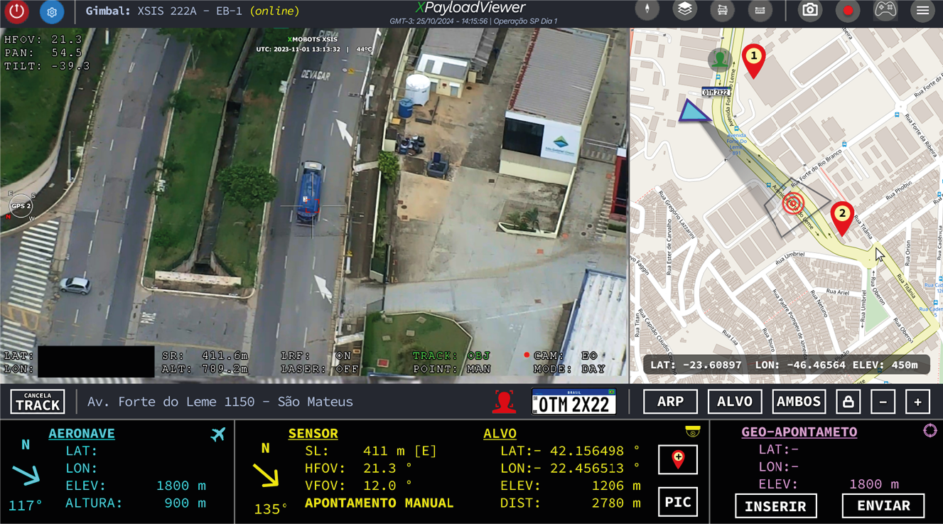
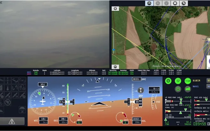
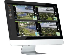
Surveillance interface with camera, map and target coordinates
Safety and comfort for operators
For operations longer than 3 hours, the Nauru has a multi-function GCS (Ground Control Station), developed to replace the traditional notebook in missions where the ergonomics of the controls and the visualization of the instrumentation are essential to reduce the workload of the operators, facilitating the success of the mission.
The GCS comes with 3 multifunctional 21.5" touchscreens, where you can see: data from the RPA's primary instrumentation, a moving map of the mission and sensor images for coordination.
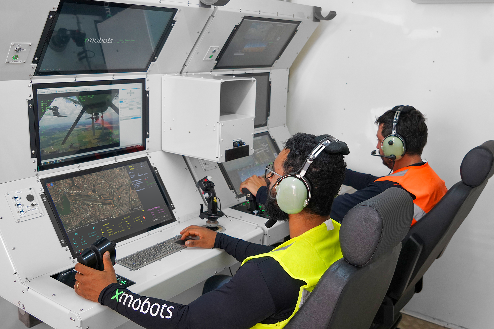
The GCS also has a robust keyboard and trackball, joystick and stick, which allow you to send changes to the areas and sensed parameters of targets by redirecting the RPA or sensors - by changing their heading, altitude, azimuth, elevation and zoom characteristics.
Portability for pilots
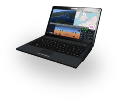
For users who choose not to purchase mobile operating units, Xmobots offers the possibility of operating the Nauru via GCS (Ground Control Station) on two ruggedized laptops equipped with XPlanner, XCockpit and XMRO software. Portable and easy to use, the solution is ideal for customers with a fixed flight site close to the operational base.
Mobile base for strategic missions
In long-duration missions aimed at security and defense operations, more than good operational ergonomics is needed to ensure the protection of the agents or operators who are in the field. For this customer profile, Xmobots offers 3 types of mobile operating base: van, towed shelter or container.
The three types of mobile base can store up to 3 Naurus 500Cs, 2 GDTs (Ground Data Terminals) and 3 GCSs, as well as housing the operations team with doors with electronic access control, emergency lighting, an HVAC system, ergonomic chairs to reduce fatigue and the possibility of installing a restroom.

The bases are configured with 3 GCSs, each with a different function:
GCS 1: Remote operation of RPA 1
GCS 2: Sensor operation and redundancy option
GCS 3: Remote operation of RPA 2

60 km range authorized by ANAC
Nauru's mobile operating centers allow for the attachment of a pneumatic mast that reaches a maximum height of 9 meters. The GDT-60A5000 data terminal consists of a datalink operating at 5 Ghz in restricted radiation and secondary character, a 1W amplifier, a parabolic directional antenna and an automatic RPA tracking system in azimuth and elevation by frequency tracking with 1 degree of accuracy. This powerful communication system gives the Nauru a range of 60 km authorized by ANAC, providing high coverage capacity for tactical missions of high strategic value.
NAURU
A UAV developed for highly complex missions, the result of years of heavy investment in R&D and manufactured 100% in Brazil.
See also

- NAURU 100D
- The Nauru 100D redefines the operational scope of military missions. With high-level intelligence, unparalleled precision and an undetectable system, this drone is an essential platform for surveillance, reconnaissance and target acquisition, and the interception...
XSIS
- 222A
- XSIS 222A is a 3-axis gimbal system designed for intelligence, security, surveillance and rescue missions.
XPATROL
- XPATROL is an advanced aerial platform for security and surveillance, with cutting-edge technology for continuous monitoring and threat detection, ideal for sensitive and extensive areas.

NAURU
- 1000C ISTAR
- The Nauru 1000C ISTAR is the Category 2 SARP chosen by the Brazilian Army to monitor Brazil's borders. Equipped with systems that allow full integration with the airspace, Xmobots' super drone combines load capacity with high performance.