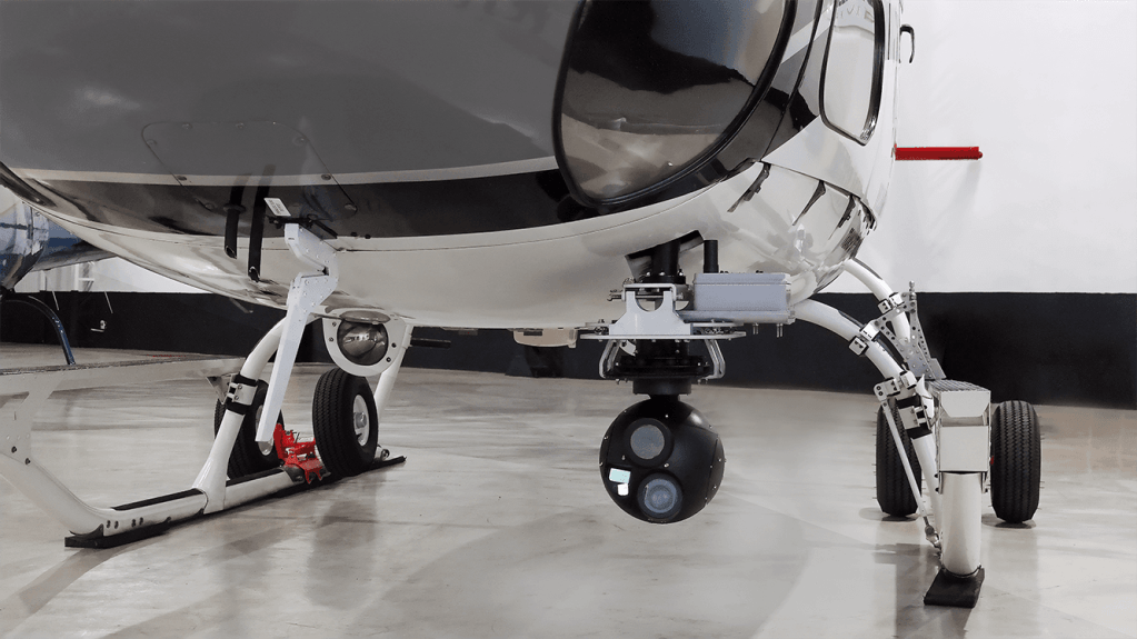
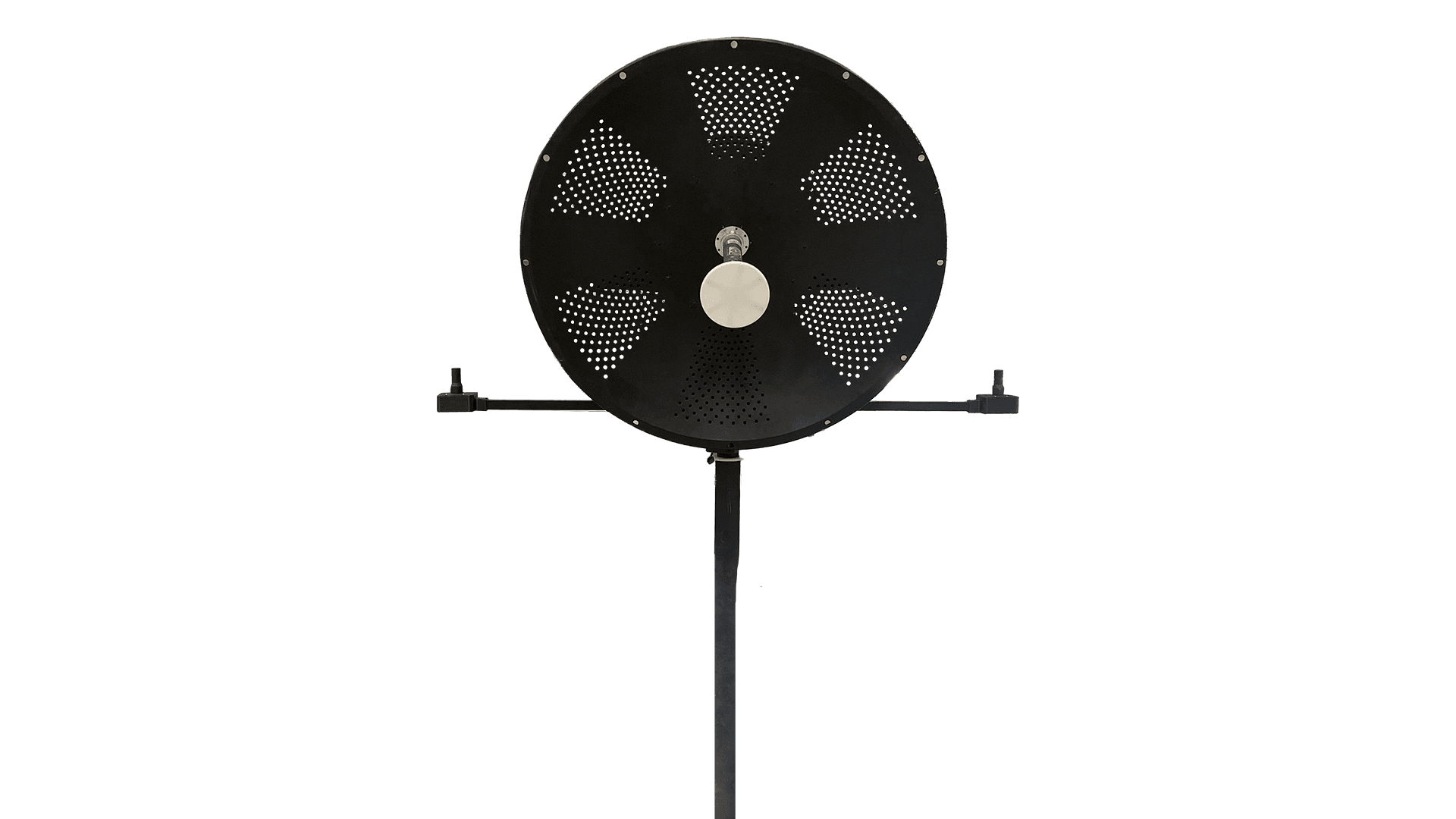
XSIS222A
The right choice for ISTAR-SAR missions
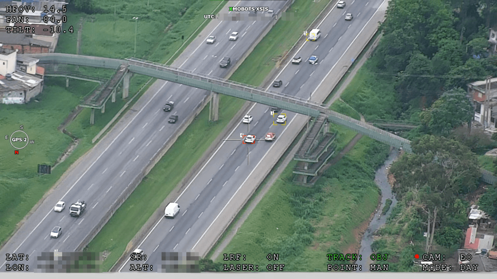
With direct gyroscopic stabilization on three axes and digital stabilization on three additional axes, the XSIS 222A is capable of long-range observation, day and night, with up to 1° field of view (FOV) in EO (SD quality) and 2° in cooled MWIR with optical zoom. The horizon is automatically leveled and stabilized.
A state-of-the-art embedded processor enables H.265 compression and MWIR color palettes. In addition, it performs coordinate pointing, scene locking, moving target identification, and tracking.
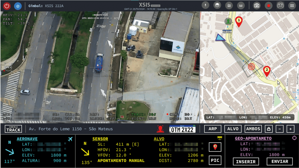
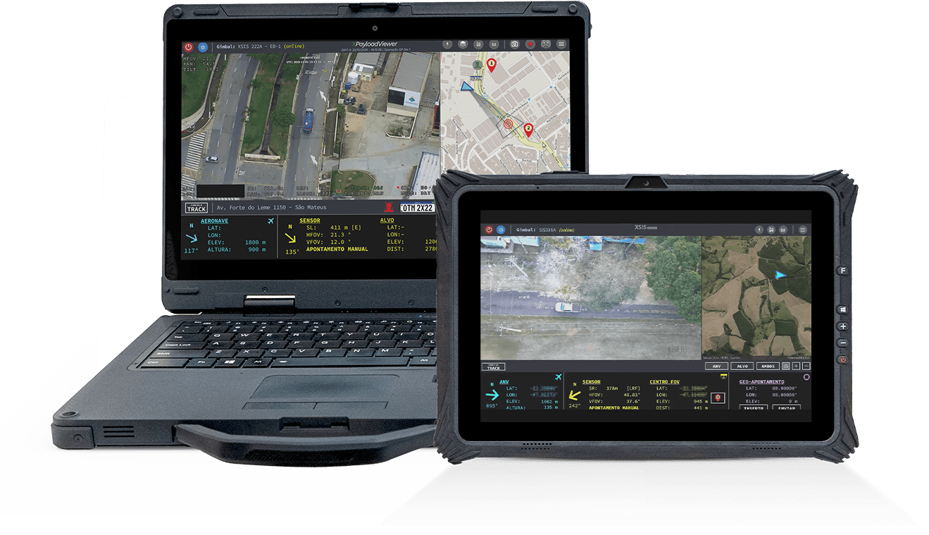
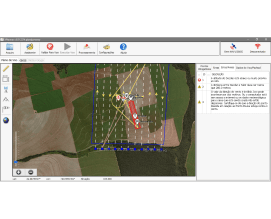
XSIS Manager, mobile mapping software that enables
the planning and execution of intelligence, surveillance,
reconnaissance, target acquisition, search and rescue missions, XSIS
222A, allows you to enter targeting coordinates, as well as
showing the coordinates of the tracked target.
Digital connection via single Ethernet cable, with open protocol.
Features
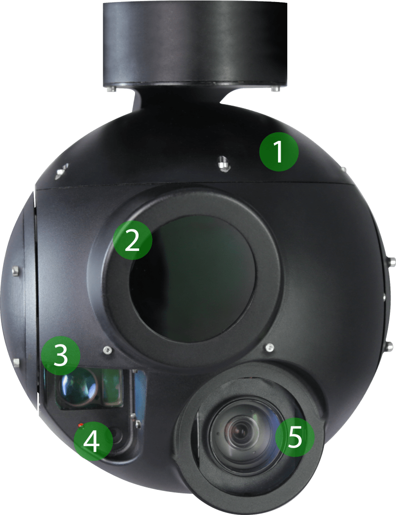
1
Weather-sealed structure
2
MWIR SD camera with 14x optical zoom
3
Rangefinder
4
IR laser pointer
5
Full HD EO camera with 30x optical zoom
GMTI: Ground Moving Target Indicator
Tracking: of fixed and moving targets on the ground (people, cars, and boats)
Target acquisition: Determination of the geographic coordinates of the target
Locking: in ground scenes
Note: for coordinates defined by the operator
Follow RPA: RPA bow monitoring
3-axis gimbal: no gimbal-lock effect at nadir
Leveling: of the horizon on the scroll axis
Direct Drive: Fast and precise mechanical stabilization
Digital Stabilization: 3-axis video stabilization
Low Maintenance: Long-life BLDC motors
Structure: robust
Weight: Less than 6 kg
Profile: 22 cm/9”
Export: NON-ITAR
Data Telemetry: KLV available
Transmission: Unicast and Multicast
Removable SD Card with Data Erase Button
Stabilization AI: vibration elimination
Mobile Map-based planning and operation software
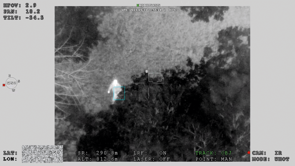
Night Surveillance with MWIR Sensor

Picture in picture
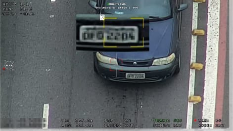
Plate reading

Target zoom at 14 km
Applications of the XSIS 222A
Intelligence, surveillance, and reconnaissance at the operational and tactical levels
Target detection, identification, and acquisition (target geolocation)
Tracking of land movements, such as vessels, trains, and groups of people
Surveillance of strategic infrastructure and sensitive areas .
Support artillery operations, including observation and fire adjustment
Analysis of damage resulting from attacks or natural disasters
Assistance in Search and Rescue (SAR) missions
Environmental monitoring and identification of fire outbreaks
Johnson's criterion (DRI) Daytime EO
Detection
Recognition
Identification
Human
Detection
15 km² – 30 km²
Recognition
4 km² – 8 km²
Identification
2 km² – 8 km²
Vehicles
Detection
30 kmᶜ
(36kmᵃ – 72 kmᵈᵇ)
Recognition
9 km² – 18 km²
Identification
5 km² – 9 km²
Vessels
Detection
(122 km – 245 km)
Recognition
30 kmᶜ
(30 kmᵃ – 62 kmᵈᵇ)
Identification
15 km² – 30 km²
Johnson's criterion (DRI) MWIR Night
Detection
Recognition
Identification
Human
Detection
6 km² – 11 km²
Recognition
2 km² – 3 km²
Identification
1 km² – 2 km²
Vehicles
Detection
14 km² – 28 km²
Recognition
4 km² – 7 km²
Identification
2 km² – 4 km²
Vessels
Detection
30 km (
) (47 km – 96 km)
Recognition
12 km² – 23 km²
Identification
6 km² – 11 km²
a- Detection probability: 90%
b- Detection probability: 50%
c- Practical value, considering normal conditions of humidity, pollution, etc.
d- Theoretical value, considering a thermal constant of 2 degrees Celsius, atmospheric attenuation factor
0.2 km-1, visual contrast 20%, illumination 1000 lux.

Helicopter operations enhanced
The XSIS222A sensor for helicopters is capable of real-time monitoring to support reconnaissance and patrol missions, surveillance, crime fighting and operations monitoring, as well as assisting in searches in urban areas and dense forests, both day and night.
Quality, long-distance images to support the fight against ultra-violent crime
Identification of vehicle characteristics (make, model and color)
Surveillance of major events, active and risk areas, during the day, at night and even in wooded areas
Image resolution for license plate reading (additional license)
Searching for and monitoring fire outbreaks
Stable group search and tracking of suspects
Search and tracking of moving or parked vehicles
Identifying people's characteristics (clothes, accessories and colors)
Image resolution for facial recognition (additional license)
Specifications
Stabilization
<85 μrad RMS, 3 eixos
Tension
24 - 26 VDC
Video interface
Digital (Ethernet)
Engine configuration
3-axis, direct drive, brushless
Encoder resolution
0.00034º, absolute
Control
Ethernet
Gyroscope sampling rate
2460Hz (Tactical Grade)
Weight
6kg
Output interface
8-pin, ruggedized waterproof connector (Meiro)
Gyroscope ARW
0.26º/√hr
Mechanical rotation limits
Pan: 360º continuous
Tilt: -90º to +10º
Roll: -45º to +45º
Power consumption
50 W typical / 140 W peak
Rotational speed
Up to 120º/s
MWIR sensor
Spectral range: 3 - 5 μm
HFOV: 28.4º - 2º
Resolution and FPS: 640 x 512 @ 30 FPS
Zoom: 14x optical
Sensor type: IDC InSb cooled
Lens type: 19 - 275 mm, f 5.5
EO sensor
HFOV: 63.7° - 2.3°. 1080p
Resolution and FPS: 1920x1080 @ 30 fps
Zoom: 30x optical / 360x digital comb.
Sensor type: 1/2.8 inch - Exmor R CMOS
Others
LRF: 2.5km NATO
IR Pointer: > 1km
Removable microSD card (up to 256GB, class 10, FAT32), optional encrypted microSD card
Video specifications and functions
Latência de vídeo: <300 ms
Video understanding: H.264, H.265. Up to 30 Mbps
Latência de controle e metadados: <90 ms
XSIS222A

See also
AMS7G
- 7th Generation Avionics System from the FW7 Platform Core technology of the Nauru 100D for more stable, safer, and smarter flights...

XPR
- Advanced reports for accurate decisions. Xmobots' XPR is software that concentrates and connects all data generated by the aircraft with the information defined in the mission, offering a complete and integrated view of the operation's results....
Portable GCS
- The Ground Control Station (GCS) is the operational center of Xmobots ARPs, concentrating essential command and control functions. Through it, the pilot controls the aircraft, monitors telemetry in real time, and manages the different payloads on board.

GCS319A
- The GCS (Ground Control Station) is the control station integrated into the Shelter system that connects the operator to the drones and their payloads, such as gimbals and radar, offering safe, efficient, and ergonomic operation, ideal for long-duration missions....
GDT
- The GDT is the terminal responsible for creating the point-to-point communication link between the ARP and the GCS. It ensures the secure and continuous exchange of commands, telemetry, and payload data throughout the mission...

XCOCKPIT
- XCOCKPIT is complete software for operating and monitoring drones, offering real-time control and detailed data analysis for efficient and safe mission management.

SIS 031A
- Maximize your power to act with the SIS031A sensor, the technology that transforms vision into strategy and intelligence. With advanced multi-target tracking, real-time distance calculation, and accurate identification, you have complete control...
XPLANNER
- XPLANNER is an air mission planning tool, guaranteeing efficiency, precision and optimization of resources, ideal for those seeking to maximize the results of air operations.