The year 2024 went down in history as one of the most devastating in terms of forest fires in Brazil. The burned area exceeded the historical average of 18.5 million hectares per year by 62%, according to the MapBiomas Annual Fire Report.
These were environmental and economic losses that impacted not only entire ecosystems, but also the lives of millions of Brazilians.
In four decades, Brazil has already recorded 206 million hectares affected by fire. This shows that we are facing a structural problem that requires continuous and multifaceted responses.
However, 2025 brought a positive change: in the first half of the year, there was a 65.8% reduction in burned areas and a 46.4% drop in hot spots compared to the same period in 2024.
The highlight goes to the Pantanal, which recorded a 97.8% drop in burned areas, and to the Amazon, with a 75.4% reduction.
This improvement did not happen by chance. It was the result of a combination of milder weather conditions and strategic prevention and control measures, such as:
- Hiring of 4,385 federal firefighters—the largest contingent ever recorded in Brazil;
- Renewal of Ibama's helicopter fleet for more agile operations;
- Implementation of the National Policy on Integrated Fire Management;
- Robust investments: R$ 405 million from the Amazon Fund to combat deforestation in nine states of the Legal Amazon and an additional R$ 150 million earmarked for the Cerrado and Pantanal.
The threat persists
Despite the progress, there is no room for complacency. The Pampa and Caatinga biomes show increases in fires and hot spots. This shows that the scenario is still heterogeneous and challenging.
Most fires are anthropogenic in origin, meaning they are caused by humans. Among the factors are:
- Careless use of fire when cleaning rural areas;
- Non-compliance with environmental standards;
- Criminal practices;
- Foci originating on highway margins.
The environmental impacts are severe: reduction of soil organic matter, death of essential microorganisms, loss of minerals, decreased water infiltration, and increased erosion and desertification.
And the damage is not only ecological. According to the National Confederation of Municipalities (CNM), more than 11 million people suffer direct impacts from the fires. In addition, financial losses exceed R$ 1.1 billion.
A real case: fire on a eucalyptus farm
The severity of the problem can be better understood by analyzing specific cases. In 2025, a private farm covering 280 hectares suffered a major fire that spread in just one day.
The result was an estimated loss of R$ 10 million, with losses that included:
- Production facilities totally or partially destroyed;
- Possible degradation of fertile soil and loss of biodiversity;
- Damage to agricultural equipment;
- Low response time compared to the speed of fire.
As a result, the lesson is clear: even well-located properties with good infrastructure are vulnerable. Without monitoring and early detection systems, the cost of a fire can mean financial ruin for producers.
Where is the risk of forest fires greatest?
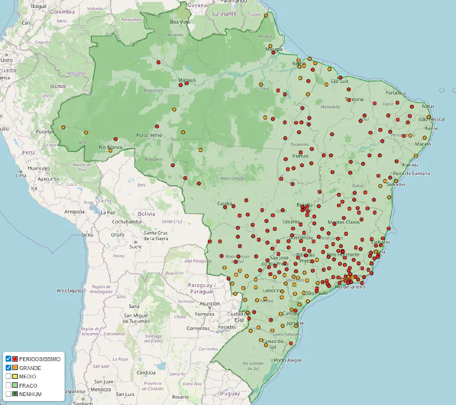
Data from the National Institute of Meteorology (Inmet) on August 5, 2025, indicate that the areas most at risk of fire are concentrated in the Southeast region.
Dry weather, combined with low relative humidity and vegetation that is more susceptible to combustion, creates an environment conducive to a small fire turning into a major disaster.
The role of technology in fighting forest fires
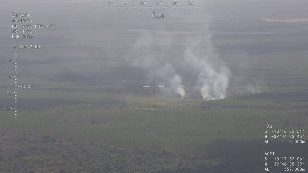
As a professional working in forest fire prevention and control, it is impossible not to highlight how much technology can change the game. The use of high-performance drones for detection, monitoring, and rapid response has become increasingly essential.
A notable example is the Nauru 500C ISR.

- You may also like: VTOL technology revolutionizes drone operations
Nauru 500C ISR: high technology at the service of forest fire prevention
The Nauru 500C ISR is a remotely piloted aircraft developed for Intelligence, Surveillance, and Reconnaissance (ISR) operations. Its characteristics make it extremely efficient for early detection of fire outbreaks:
- Long flight range: capable of covering 60 km without the need for multiple landings;
- Remote detection: the gimbal attached to the aircraft can identify a fire source 30 km away;
- Thermal camera: high-resolution thermal imaging camera that allows you to identify heat spots invisible to the naked eye;
- VTOL technology: no need for runways, favoring use in forest environments;
- Real-time transmission: sends images and data directly to command centers, enabling quick decisions;
- Low operating costs compared to helicopters and manned aircraft.
Using the Nauru 500C ISR in forest firefighting operations means gaining precious minutes in detecting hotspots. After all, when it comes to fire, every minute counts in preventing an isolated hotspot from becoming a major fire.
Thus, in a country of continental dimensions such as Brazil, integrating equipment such as the Nauru 500C ISR into prevention and response strategies is more than a trend—it is a necessity for preserving lives, ecosystems, and local economies.
Are you curious to learn more about this technology? Talk to our experts and schedule an exclusive demonstration.